Shim'a
שִׁמְעָה / יוֹנָדָב | |
|---|---|
| Hebrew transcription(s) | |
| • official | Yonadav |
 | |
  Shim'a | |
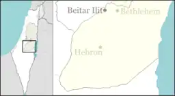
| Coordinates: 31°23′16″N 35°0′46″E / 31.38778°N 35.01278°E | |
| District | Judea and Samaria Area |
| Council | Har Hevron |
| Region | West Bank |
| Affiliation | Amana |
| Founded | 1982 |
| Population (2021)[1] | 886 |
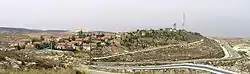
Shim'a (Hebrew: שִׁמְעָה), also Yonadav (Hebrew: יוֹנָדָב), is an Israeli settlement in the West Bank, along the Green Line south of Livne and Teneh Omarim. Located on a hill 600 metres above sea level, it is organised as a community settlement and falls under the jurisdiction of Har Hevron Regional Council. In 2021 it had a population of 886.
The international community considers Israeli settlements in the West Bank illegal under international law, but the Israeli government disputes this.[2]
Name
Shim'a/Yonadav is named after King David's brother Shimeah and his son Jonadab (2 Samuel 13:3).[3]
History
The settlement was first established in 1982 as a pioneer Nahal military outpost, and demilitarized when turned over to residential purposes in 1988. As of 2015, Shim'a had approximately 600 residents.
References
- ↑ "Regional Statistics". Israel Central Bureau of Statistics. Retrieved 22 February 2023.
- ↑ "The Geneva Convention". BBC News. 10 December 2009. Retrieved 27 November 2010.
- ↑ Bitan, Hanna: 1948-1998: Fifty Years of 'Hityashvut': Atlas of Names of Settlements in Israel, Jerusalem 1999, Carta, p. 68, ISBN 965-220-423-4 (in Hebrew)
External links
- Shim'a Archived 2011-07-21 at the Wayback Machine Amana
- Shim'a Peace Now