Davis Lake volcanic field | |
|---|---|
 | |
| Location | Deschutes / Klamath counties, Oregon, U.S. |
| Range | Cascades |
| Age | Holocene |
| Geology | Cinder cone, Lava flow, and shield volcano[1] |
| Volcanic arc | Cascade Volcanic Arc[1] |
| Last eruption | 2790 BC (?)[1] |
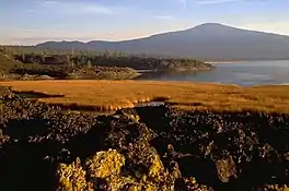
The Davis Lake volcanic field, is a volcanic field with a group of andesitic cinder cones, lava flows and basaltic andesite shield volcano. The field is located east of the Cascade Range of Oregon, United States.[1]
Nearby volcanoes
| Name | Elevation | Coordinates |
| Davis Mountain[1] | 6,624 ft (2,019 m) | 43°37′45″N 121°46′00″W / 43.6292878°N 121.7666941°W[2] |
| Odell Butte[1] | 7,011 ft (2,137 m) | 43°28′15″N 121°51′50″W / 43.4709584°N 121.8639165°W[3] |
See also
References
This article is issued from Wikipedia. The text is licensed under Creative Commons - Attribution - Sharealike. Additional terms may apply for the media files.