Kham Khuean Kaeo
คำเขื่อนแก้ว | |
|---|---|
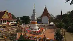 Phra That Ku Chan, an ancient pagoda in Ku Chan Sub-District, Kham Khuean Kaeo District | |
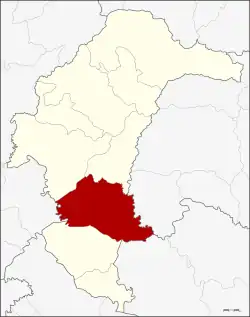 District location in Yasothon province | |
| Coordinates: 15°39′11″N 104°18′32″E / 15.65306°N 104.30889°E | |
| Country | Thailand |
| Province | Yasothon |
| Seat | Lumphuk |
| Area | |
| • Total | 638.40 km2 (246.49 sq mi) |
| Population (2008) | |
| • Total | 68,606 |
| • Density | 109.85/km2 (284.5/sq mi) |
| Time zone | UTC+7 (ICT) |
| Postal code | 35110 |
| Geocode | 3504 |
Kham Khuean Kaeo (Thai: คำเขื่อนแก้ว, pronounced [kʰām kʰɯ̀a̯n kɛ̂ːw]) is a district (amphoe) of Yasothon province in northeastern Thailand.
History
In 1917, the district was renamed Lumphuk after its central sub-district.[1] In 1953 it was returned to its original name, Kham Khuean Kaeo.[2]
When Yasothon was separated from Ubon Ratchathani province, Kham Khuean Kaeo was one of the districts which was assigned to the new province.[3]
Geography
Neighboring districts are (from the northwest clockwise): Mueang Yasothon and Pa Tio of Yasothon Province; Hua Taphan of Amnat Charoen province; Khueang Nai of Ubon Ratchathani province; Maha Chana Chai of Yasothon Province; and Phanom Phrai of Roi Et province.
Administration
The district is divided into 13 sub-districts (tambons) which make up 115 villages (mubans). Kham Khuean Kaeo is a sub-district municipality (thesaban tambon) which covers parts of the sub-district Lumphuk. Each of the sub-districts have a tambon administrative organization (TAO).
| No. | Name | Thai | Villages | Pop.[4] |
|---|---|---|---|---|
| 1. | Lumphuk | ลุมพุก | 15 | 13,044 |
| 2. | Yo | ย่อ | 11 | 6,579 |
| 3. | Song Pueai | สงเปือย | 9 | 4,346 |
| 4. | Phon Than | โพนทัน | 5 | 3,450 |
| 5. | Thung Mon | ทุ่งมน | 9 | 6,032 |
| 6. | Na Kham | นาคำ | 6 | 2,765 |
| 7. | Dong Khaen Yai | ดงแคนใหญ่ | 13 | 7,904 |
| 8. | Ku Chan | กู่จาน | 12 | 5,952 |
| 9. | Na Kae | นาแก | 8 | 3,624 |
| 10. | Kut Kung | กุดกุง | 7 | 4,657 |
| 11. | Lao Hai | เหล่าไฮ | 6 | 2,960 |
| 12. | Khaen Noi | แคนน้อย | 7 | 3,615 |
| 13. | Dong Charoen | ดงเจริญ | 7 | 3,678 |
References
- ↑ ประกาศกระทรวงมหาดไทย เรื่อง เปลี่ยนชื่ออำเภอ (PDF). Royal Gazette (in Thai). 34 (ก): 40–68. 1917-04-29. Archived from the original (PDF) on November 7, 2011.
- ↑ พระราชกฤษฎีกาเปลี่ยนชื่ออำเภอและตำบลบางแห่ง พ.ศ. ๒๔๙๖ (PDF). Royal Gazette (in Thai). 70 (25 ก): 492–496. 1953-04-14. Archived from the original (PDF) on May 24, 2012.
- ↑ ประกาศของคณะปฏิวัติ ฉบับที่ ๗๐ (PDF). Royal Gazette (in Thai). 89 (21 ก ฉบับพิเศษ): 1–3. 1972-02-07. Archived from the original (PDF) on June 7, 2012.
- ↑ "Population statistics 2008". Department of Provincial Administration. Archived from the original on 2009-08-20.
External links
- amphoe.com (Thai)