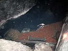
Kow Ata (also The Bakharlyn) is an underground lake in an eponymous cave near Bäherden in Turkmenistan, at the foot of the Kopet Dag.[1][2] It is the largest in Commonwealth of Independent States.[3]
History
The landform was first documented by archaeologists in 1856.[1] Coverage by the local press in 1896—noting the authorities of Bäherden rail-station to have had a wooden staircase installed for safe descent—led to tourists from Ashgabat flocking the site.[1][3]
In 1960s, a road was constructed to the cave, electricity supplied, and hotels built in nearby areas.[3]
Geology
Cave
The cave has a length of 250 m and variable width of 12–50 m.[2] There are five entrances.[2]
Lake
The lake is at a depth of 55 metres (180 ft) from the 3rd (by height) cave entrance;[lower-alpha 1] no sunlight reaches the cave.[4][5] Length is reported to lie between 75 metres (246 ft) and 80 metres (260 ft); breadth varies, across the length, between 8 metres (26 ft) and 23 metres (75 ft).[2][3] Average depth is about 10 metres (33 ft); maximum depth is 15 metres (49 ft).[6]
Limnology
The temperature of the lake remains roughly constant throughout the year, between 33 °C (91 °F) and 38 °C (100 °F).[4] The water has a high mineral content[lower-alpha 2] and is especially rich in sulfur.[4] The water is transparent with a shade of bluish green.[5]
Flora and fauna
Bats, rodents, birds, and about 50 invertebrate species inhabit the cave.[2]
Tourism
Bathing is permitted in Kow Ata, making it a prominent weekend destination for residents of Ashgabat.[4] A long-winding illuminated staircase leads to the cave.[7][6] Changing cubicles and an observation platform are provided at about 80% length of the stair-route.[8] There are no safety features except a tape warning swimmers to not proceed beyond.[8]
Healing
Balneotherapy is practiced.[2]
Notes
References
- 1 2 3 "Золотой век". 2017-07-04. Archived from the original on 2017-07-04. Retrieved 2021-11-03.
- 1 2 3 4 5 6 "БАХАРДЕНСКАЯ ПЕЩЕРА • Большая российская энциклопедия - электронная версия". bigenc.ru. Archived from the original on 2020-09-26. Retrieved 2021-11-03.
- 1 2 3 4 "Подземное озеро Ков-Ата – чудо природы". Партнерство для Инноваций (in Russian). 2017-11-27. Retrieved 2021-11-03.
- 1 2 3 4 Brummell, Paul (2005). Turkmenistan. Bradt Travel Guides. pp. 116–117. ISBN 978-1-84162-144-9.
- 1 2 3 orient.tm https://orient.tm/ru/unikalnoe-tvorenie-prirody-skazochnaya-peshhera-kov-ata. Retrieved 2021-11-03.
{{cite web}}: Missing or empty|title=(help) - 1 2 3 "Ков-ата - подземное, целебное озеро (+инфографика) • Alpagama". Alpagama (in Russian). 2016-03-12. Retrieved 2021-11-03.
- ↑ turkmenportal. "Подземное озеро Ков-Ата – чудо природы". Туркменистан, интернет портал о культурной, деловой и развлекательной жизни в Туркменистане (in Russian). Retrieved 2021-11-03.
- 1 2 "Kow Ata | Turkmenistan Travel Guide - Koryo Tours". koryogroup.com. 5 March 2020. Retrieved 2021-11-03.