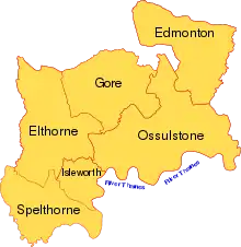
The historic county of Middlesex, England divided into the six hundreds.

List of the parishes in Middlesex, grouped by hundred, as of 1831.

The historic county of Middlesex was recorded in the Domesday Book as being divided into the six hundreds of Edmonton, Elthorne, Gore, Hounslow (Isleworth in all later records),[1] Ossulstone and Spelthorne, as follows:

HundredParishesArea (1831)
acres[2]
Edmonton[3]Edmonton (All Saints) • Enfield (St Andrew) • Monken Hadley • South Mimms (St Giles) • Tottenham (All Saints)31,410
Elthorne[4]Cowley (St Lawrence) • Cranford (St Dunstan) • Greenford • Hanwell (St Mary) • Harefield (St Mary) • Harlington • Harmondsworth (St Mary) • Hayes (St Mary the Virgin) • Hillingdon • Ickenham (St Giles) • New Brentford • Northolt • Norwood • Perivale (St Mary the Virgin) • Ruislip (St Martin) • Uxbridge Hamlet • West Drayton (St Martin)35,690
Gore[5]Edgware (St Margaret) • Great Stanmore (St John) • Harrow on the Hill (St Mary) • Hendon (St Mary) • Kingsbury (St Andrew) • Little Stanmore (St Lawrence) • Pinner (St John)28,660
Isleworth[6]Heston (St Leonard) • Isleworth (All Saints) • Twickenham (St Mary the Virgin)9,280
Ossulstone[7]Acton (St Mary) • Bethnal Green • Bow • Bromley • Charter House • Chelsea (All Saints) • Chiswick (St Nicholas) • Clerkenwell • Duchy of Lancaster • Ealing (St Mary) • Finchley (St Mary) • Friern Barnet • Fulham (All Saints) • Furnival's Inn • Glasshouse Yard • Gray's Inn • Hackney • Hammersmith (St Paul) • Hampstead (St John) • Holy Trinity Minories • Hornsey • Islington (St Mary) • Kensington (St Mary Abbots) • Liberty of Saffron Hill, Hatton Garden, Ely Rents and Ely Place • Liberty of the Rolls • Limehouse • Lincoln's Inn • Mile End New Town • Mile End Old Town • Norton Folgate • Old Artillery Ground • Old Tower Without • Paddington • Poplar • Precinct of the Savoy • Ratcliffe • Shadwell • Shoreditch • Spitalfields • (St Andrew) Holborn • Staple Inn • St Botolph Aldersgate • St Botolph without Aldgate • St Clement Danes • Stepney (St Dunstan) • (St George) Bloomsbury • St George in the East • St George the Martyr • St Giles in the Fields • St Katharine's by the Tower • St Luke • St Marylebone • St Mary le Strand • Stoke Newington • St Pancras • St Sepulchre • Wapping • West Twyford • Whitechapel • Willesden (St Mary the Virgin) [Links incomplete]47,950
Spelthorne[8]Ashford (St Michael) • East Bedfont (St Mary the Virgin) • Feltham (St Dunstan) • Hampton (St Mary the Virgin) • Hampton Wick • Hanworth (St George) • Laleham (All Saints) • Littleton • Shepperton (St Nicholas) • Staines (St Mary) • Stanwell (St Mary the Virgin) • Sunbury (St Mary the Virgin) • Teddington (St Mary)23,500

The City of London (i.e., the original ″Square Mile″) was geographically located within Middlesex (and was bounded by the hundred of Ossulstone to the west, north and east) but was essentially independent of the county for most purposes.

References

  1. ↑ "The hundred of Isleworth". A History of the County of Middlesex: Volume 3. 1962. Retrieved 20 February 2008.
  2. ↑ Great Britain Historical GIS / University of Portsmouth, Middlesex hundreds 1831 census population. Retrieved 2008-02-20.
  3. ↑ Great Britain Historical GIS / University of Portsmouth, Edmonton hundred. Retrieved 2018-01-22.
  4. ↑ Great Britain Historical GIS / University of Portsmouth, Elthorne hundred. Retrieved 2018-01-22.
  5. ↑ Great Britain Historical GIS / University of Portsmouth, Gore hundred. Retrieved 2018-01-22.
  6. ↑ Great Britain Historical GIS / University of Portsmouth, Isleworth hundred. Retrieved 2018-01-22.
  7. ↑ Great Britain Historical GIS / University of Portsmouth, Ossulstone hundred. Retrieved 2018-01-22.
  8. ↑ Great Britain Historical GIS / University of Portsmouth, Spelthorne hundred. Retrieved 2018-01-22.
This article is issued from Wikipedia. The text is licensed under Creative Commons - Attribution - Sharealike. Additional terms may apply for the media files.