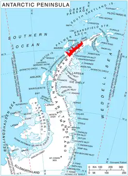
Location of Danco Coast.
Pishtachev Peak (Bulgarian: Пищачев връх, romanized: Pishtachev vrah, IPA: [piˈʃtat͡ʃɛv ˈvrɤx]) is the rocky, partly ice-free peak rising to 1283 m[1] between Rozier Glacier and Blanchard Glacier on Danco Coast in Graham Land, Antarctica.
The feature is named after the Bulgarian cartographer Toma Pishtachev (1876-1955).
Location
Pishtachev Peak is located at 64°44′00″S 62°06′27″W / 64.73333°S 62.10750°W, which is 5.3 km east of Sophie Cliff, 5.67 km south-southeast of Garnerin Point, and 5.57 km southwest of Sadler Point. British mapping in 1980.
Maps
- Antarctic Digital Database (ADD). Scale 1:250000 topographic map of Antarctica. Scientific Committee on Antarctic Research (SCAR). Since 1993, regularly upgraded and updated.
Notes
- ↑ Reference Elevation Model of Antarctica. Polar Geospatial Center. University of Minnesota, 2019
References
- Pishtachev Peak. SCAR Composite Antarctic Gazetteer.
- Bulgarian Antarctic Gazetteer. Antarctic Place-names Commission. (details in Bulgarian, basic data in English)
External links
- Pishtachev Peak. Copernix satellite image
This article includes information from the Antarctic Place-names Commission of Bulgaria which is used with permission.
This article is issued from Wikipedia. The text is licensed under Creative Commons - Attribution - Sharealike. Additional terms may apply for the media files.