Sangkhom
สังคม | |
|---|---|
 Sunrise over the Mekong River | |
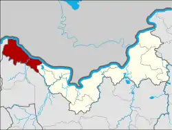 District location in Nong Khai province | |
| Coordinates: 18°3′51″N 102°16′24″E / 18.06417°N 102.27333°E | |
| Country | Thailand |
| Province | Nong Khai |
| Seat | Kaeng Kai |
| Area | |
| • Total | 449.7 km2 (173.6 sq mi) |
| Population (2005) | |
| • Total | 22,998 |
| • Density | 51.1/km2 (132/sq mi) |
| Time zone | UTC+7 (ICT) |
| Postal code | 43160 |
| Geocode | 4308 |
Sangkhom (Thai: สังคม, pronounced [sǎŋ.kʰōm]) is the westernmost district (amphoe) of Nong Khai province, northeastern Thailand.
Geography
Neighboring districts are (from the east clockwise): Si Chiang Mai and Pho Tak of Nong Khai Province; Na Yung of Udon Thani province; and Pak Chom of Loei province. To the north across the Mekong River is the Lao province Vientiane Prefecture.
History
Originally the area was a tambon of Tha Bo district, which became part of the newly established Si Chiang Mai district on 4 August 1958. It was established as a minor district (king amphoe) on 1 March 1966,[1] and upgraded to a full district on 16 November 1971.[2] From 14 November 1975 to 14 November 1978 the district was under military administration as part of a military operation.
Symbols
The district slogan is "Naga Fireball Festival; famous dried bananas; golden beaches".
Administration
The district is divided into five sub-districts (tambons), which are further subdivided into 36 villages (mubans). Sangkhom is a township (thesaban tambon) which covers parts of tambons Sangkhom and Kaeng Kai. There are a further five tambon administrative organizations (TAO).
| No. | Name | Thai name | Villages | Pop. | |
|---|---|---|---|---|---|
| 1. | Kaeng Kai | แก้งไก่ | 6 | 4,304 | |
| 2. | Pha Tang | ผาตั้ง | 7 | 5,724 | |
| 3. | Ban Muang | บ้านม่วง | 7 | 3,030 | |
| 4. | Na Ngio | นางิ้ว | 9 | 6,094 | |
| 5. | Sangkhom | สังคม | 7 | 3,846 |
References
- ↑ ประกาศกระทรวงมหาดไทย เรื่อง แบ่งท้องที่ตั้งเป็นกิ่งอำเภอ (กิ่งอำเภอสังคม อำเภอศรีเชียงใหม่ จังหวัดหนองคาย) (PDF). Royal Gazette (in Thai). 83 (19 ง): 997. March 1, 1966. Archived from the original (PDF) on February 24, 2012.
- ↑ พระราชกฤษฎีกาตั้งอำเภอปลาปาก อำเภอเชียงกลาง อำเภอปากชม อำเภอบ้านม่วง อำเภอพังโคน อำเภอดอนสัก อำเภอพนม อำเภอเวียงสระ อำเภอสังคม และอำเภอหัวตะพาน พ.ศ. ๒๕๑๔ (PDF). Royal Gazette (in Thai). 88 (123 ก): 745–748. November 16, 1971. Archived from the original (PDF) on February 24, 2012.