Tauranga South | |
|---|---|
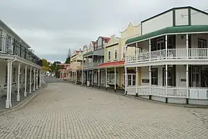 Historic Village on 17th Avenue | |
| Coordinates: 37°42′22″S 176°09′18″E / 37.706°S 176.155°E | |
| Country | New Zealand |
| City | Tauranga |
| Local authority | Tauranga City Council |
| Electoral ward | Te Papa General Ward |
| Area | |
| • Land | 433 ha (1,070 acres) |
| Population (June 2022)[2] | |
| • Total | 7,460 |
| Hospitals | Tauranga Hospital |
| Judea | (Waikareao Estuary) | Tauranga Central |
  Tauranga South Tauranga South  |
(Tauranga Harbour) | |
| Gate Pa | (Waimapu Estuary) | Maungatapu |
Tauranga South is a suburb of Tauranga, on New Zealand's North Island. It is located south-east of Judea, north-east of Gate Pa and south-west of Tauranga Central.
Property prices in the suburb have risen sharply,[3] largely due to demand for land in the area.[4]
The suburb has a bowls club which hosts bowls players from across the country.[5]
Demographics
Tauranga South covers 4.33 km2 (1.67 sq mi)[1] and had an estimated population of 7,460 as of June 2022,[2] with a population density of 1,723 people per km2.
| Year | Pop. | ±% p.a. |
|---|---|---|
| 2006 | 6,255 | — |
| 2013 | 6,258 | +0.01% |
| 2018 | 6,888 | +1.94% |
| Source: [6] | ||
Tauranga South had a population of 6,888 at the 2018 New Zealand census, an increase of 630 people (10.1%) since the 2013 census, and an increase of 633 people (10.1%) since the 2006 census. There were 2,745 households, comprising 3,327 males and 3,558 females, giving a sex ratio of 0.94 males per female, with 1,167 people (16.9%) aged under 15 years, 1,230 (17.9%) aged 15 to 29, 3,039 (44.1%) aged 30 to 64, and 1,452 (21.1%) aged 65 or older.
Ethnicities were 72.3% European/Pākehā, 19.4% Māori, 4.1% Pacific peoples, 14.2% Asian, and 1.7% other ethnicities. People may identify with more than one ethnicity.
The percentage of people born overseas was 24.7, compared with 27.1% nationally.
Although some people chose not to answer the census's question about religious affiliation, 44.1% had no religion, 39.2% were Christian, 2.4% had Māori religious beliefs, 2.0% were Hindu, 1.1% were Muslim, 0.5% were Buddhist and 4.3% had other religions.
Of those at least 15 years old, 1,161 (20.3%) people had a bachelor's or higher degree, and 1,116 (19.5%) people had no formal qualifications. 759 people (13.3%) earned over $70,000 compared to 17.2% nationally. The employment status of those at least 15 was that 2,541 (44.4%) people were employed full-time, 783 (13.7%) were part-time, and 234 (4.1%) were unemployed.[6]
| Name | Area (km2) | Population | Density (per km2) | Households | Median age | Median income |
|---|---|---|---|---|---|---|
| Tauranga Hospital | 1.94 | 2,058 | 1,061 | 777 | 39.3 years | $24,300[7] |
| Tauranga South | 2.39 | 4,830 | 2,021 | 1,968 | 44.4 years | $28,300[8] |
| New Zealand | 37.4 years | $31,800 |
Economy
Fraser Cove shopping centre opened in Tauranga South in 2002. It covers 32,500 m² with 1235 carparks.[9] The mall has 35 shops, including The Warehouse and a Countdown supermarket.[10]
Education
Tauranga Intermediate is New Zealand's largest co-educational state intermediate school,[11][12] with a roll of 1237 as of April 2023.[13]
Tauranga Boys' College is a state secondary school for boys established in 1958,[14][15] with a roll of 2200.[16]
St Mary's Catholic School is a co-educational state-integrated Catholic school,[17][18] with a roll of 414.[19]
Tauranga Special School, Tauranga's only school for students with special learning needs,[20] is also located in Tauranga South.[21][22]
References
- 1 2 "ArcGIS Web Application". statsnz.maps.arcgis.com. Retrieved 19 December 2022.
- 1 2 "Population estimate tables - NZ.Stat". Statistics New Zealand. Retrieved 25 October 2022.
- ↑ Hunter, Zoe (2 March 2020). "OneRoof property report: Tauranga's hotspots revealed". New Zealand Media and Entertainment. Bay of Plenty Times.
- ↑ Olivier, Cira (27 January 2020). "Special Report: Which Tauranga suburb has land worth more than the house?". New Zealand Media and Entertainment. Bay of Plenty Times.
- ↑ "Bowls Tauranga South hosts annual Cooper Crest Invitation Ladies' Pairs tournament". New Zealand Media and Entertainment. Bay of Plenty Times. 12 April 2019.
- 1 2 "Statistical area 1 dataset for 2018 Census". Statistics New Zealand. March 2020. Tauranga Hospital (194400) and Tauranga South (194800).
- ↑ 2018 Census place summary: Tauranga Hospital
- ↑ 2018 Census place summary: Tauranga South
- ↑ "Fraser Cove - NZRPG". frasercoveshoppingcentre.co.nz. NZRPG.
- ↑ "Fraser Cove - Stores". frasercoveshoppingcentre.co.nz. NZRPG.
- ↑ "Tauranga Intermediate Official School Website". tauranga-int.school.nz.
- ↑ "Tauranga Intermediate Ministry of Education School Profile". educationcounts.govt.nz. Ministry of Education.
- ↑ "Tauranga Intermediate Education Review Office Report". ero.govt.nz. Education Review Office.
- ↑ "Tauranga Boys' College Official School Website". tbc.school.nz.
- ↑ "Tauranga Boys' College Ministry of Education School Profile". educationcounts.govt.nz. Ministry of Education.
- ↑ "Tauranga Boys' College Education Review Office Report". ero.govt.nz. Education Review Office.
- ↑ "St Mary's Catholic School Official School Website". stmarystga.school.nz/.
- ↑ "St Mary's Catholic School Ministry of Education School Profile". educationcounts.govt.nz. Ministry of Education.
- ↑ "St Mary's Catholic School Education Review Office Report". ero.govt.nz. Education Review Office.
- ↑ "Tauranga Special School Education Review Office Report". ero.govt.nz. Education Review Office.
- ↑ "Tauranga Special School Official School Website". taurangaspecialschool.nz.
- ↑ "Tauranga Special School Ministry of Education School Profile". educationcounts.govt.nz. Ministry of Education.